
The Poetry of Meandering Rivers: Understanding Their Beauty and Geoscience
Dive into the captivating world of meandering rivers, where beauty meets geoscience. Discover the forces shaping their winding paths, the stories hidden in their sediments, and how geoinformatics unlocks their secrets. Explore famous meanders like the Mississippi and Amazon through stunning imagery. Click to uncover the elegance of Earth’s dynamic waterways.
GEOINFORMATICS
Dr Mahesha BR Pandit
7/20/20243 min read
The Poetry of Meandering Rivers: Understanding Their Beauty and Geoscience
Rivers, with their serpentine paths, have inspired poets, artists, and scientists alike. Meandering rivers, in particular, evoke a sense of wonder and curiosity. Their winding courses seem like nature’s brushstrokes across the landscape, but beneath their beauty lies a fascinating interplay of geology, hydrology, and time. From the way they shape ecosystems to the stories they tell about Earth's dynamic processes, meandering rivers are a testament to the planet's ever-changing surface.
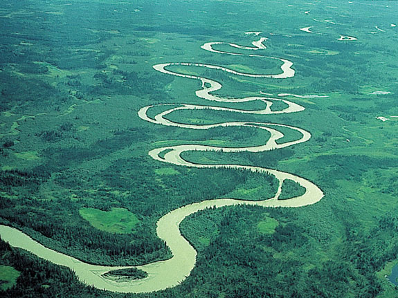
The Science Behind the Meander
A meander is not just a random curve; it is the result of precise natural dynamics. Meandering rivers develop in gently sloping terrains where the flow of water lacks the energy to cut a straight path. As water flows, it encounters variations in the riverbed, leading to areas of faster and slower currents. Faster currents erode the outer banks, while slower currents deposit sediment along the inner curves. Over time, these processes carve the characteristic sinuous patterns.
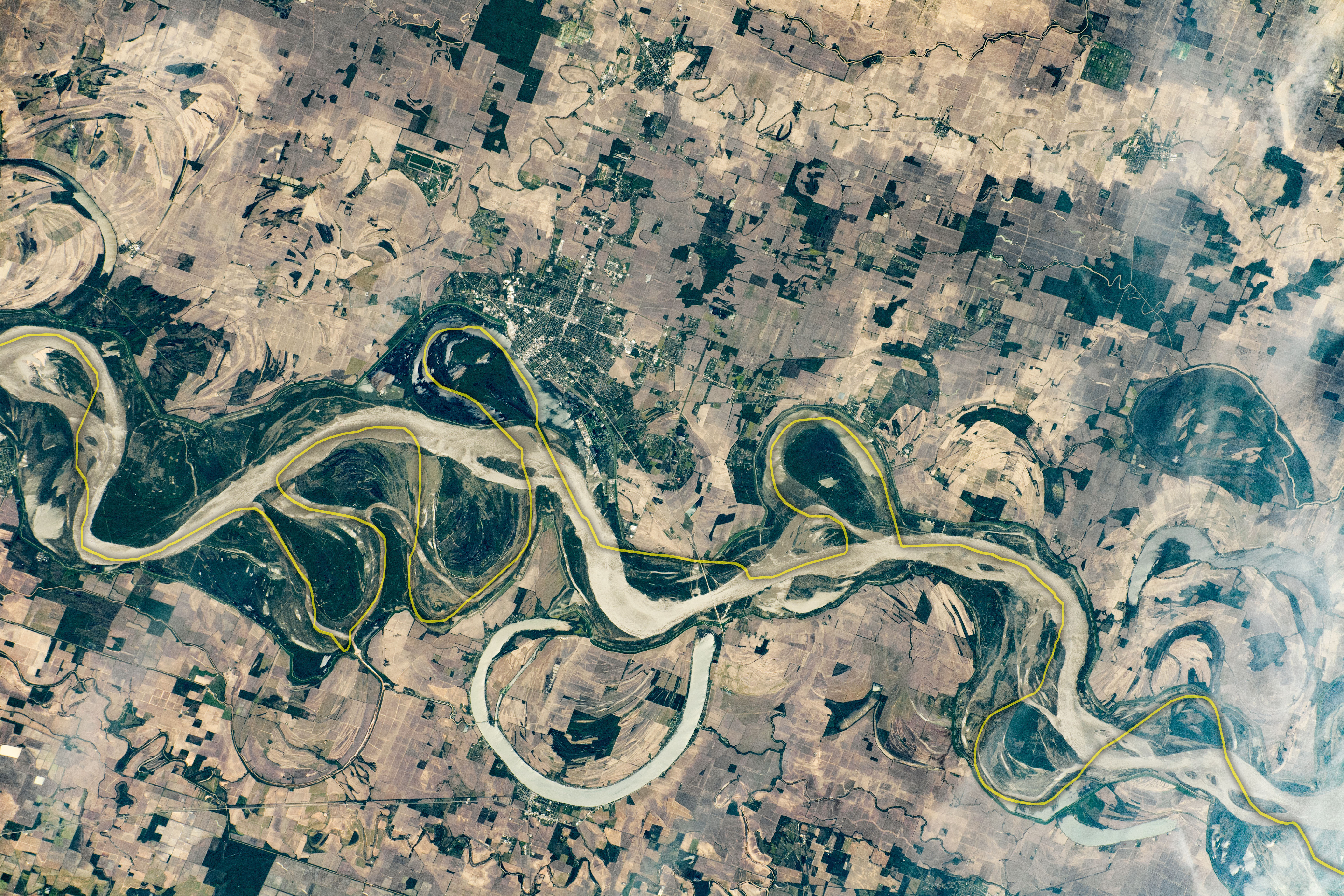
From a geoinformatics perspective, studying meandering rivers involves examining the interplay of factors such as gradient, sediment load, and discharge rates. High-resolution satellite imagery and geographic information systems (GIS) tools allow researchers to monitor changes in river courses over time. These tools help identify erosion hotspots, sediment deposition zones, and even predict future meandering behavior.
Rivers as Geoscience Narratives
Meandering rivers are more than just physical features; they are natural archives that document the interaction between water and land. They reveal clues about the climate, vegetation, and geological history of their regions. By analyzing the sediments deposited in their floodplains, geoscientists can reconstruct past climates and trace changes in ecosystems.
These rivers also play a critical role in shaping the land. They create fertile floodplains, support biodiversity, and sustain agricultural activities. Their patterns influence urban planning and water resource management, as they are often key sources of freshwater and irrigation.
Famous Meandering Rivers and Their Picturesque Landscapes
Some of the world’s most iconic meandering rivers have become symbols of natural beauty and geological marvels. Each has a story to tell, both in its flow and in the landscapes it sculpts.
The Mississippi River, USA: The Mississippi is one of the most studied meandering rivers, with its dramatic loops and oxbow lakes. Satellite imagery reveals its complex patterns. View the Mississippi’s meanders.
The Amazon River, Brazil: In its vast journey through the rainforest, the Amazon's meandering paths create countless oxbow lakes and wetlands that teem with life. Explore the Amazon's curves.
The Rhine River, Europe: The Rhine's meanders are surrounded by historical towns and lush vineyards, offering a blend of geological and cultural significance. Discover the Rhine’s winding beauty
The Ganga River, India: As it descends from the Himalayas, the Ganga forms meanders across the plains of northern India, creating one of the most fertile regions in the world. See the Ganga’s meanders.
The Nile River, Egypt: Even in the arid landscape of Egypt, the Nile exhibits subtle meandering patterns that have supported civilizations for millennia. Marvel at the Nile’s flow.
The Elegance of Meanders in Geoinformatics
Modern geoinformatics has revolutionized the way we study meandering rivers. Through remote sensing and GIS, we can map river courses, monitor erosion, and assess flood risks with remarkable precision. Temporal data from satellites allow scientists to observe the evolution of meanders, identifying areas where rivers are shifting their courses or creating oxbow lakes.
In regions prone to flooding, these tools provide critical insights that guide disaster preparedness and infrastructure development. By understanding the natural rhythm of meanders, geoinformatics helps balance human needs with ecological preservation.
The Enduring Beauty of Meandering Rivers
Meandering rivers remind us of the harmony between chaos and order in nature. Their graceful curves may appear effortless, but they are born of complex processes shaped by water’s persistent flow. Through the lens of geoinformatics, we see them not only as natural wonders but as dynamic systems that hold the keys to understanding our planet’s past and securing its future.
Whether viewed from a poet’s eye or a geoscientist’s tools, meandering rivers captivate with their timeless beauty and the stories they tell about Earth's ever-changing surface. These rivers are a testament to the power of time, movement, and the interconnectedness of nature.
Image Courtesy: Sam Manthey Geography, https://sammanthey.wordpress.com/2015/04/03/meandering-rivers-make-poor-political-boundaries/