Decoding Earth's Secrets: How Band Ratios Unlock Vital Insights from Remote Sensing
Discover the power of band ratios in remote sensing, a technique that decodes Earth's hidden patterns. Learn how they reveal insights about vegetation health, water quality, mineral deposits, and climate impacts. Dive into this engaging blog to see how these tools transform environmental research and unlock the planet's secrets.
GEOINFORMATICS
Dr Mahesha BR Pandit
3/20/20244 min read


Decoding Earth's Secrets: How Band Ratios Unlock Vital Insights from Remote Sensing
The Earth tells its story through patterns and changes, a narrative that can often go unnoticed by the naked eye. Remote sensing has emerged as a powerful tool to uncover these hidden details, offering a deeper understanding of the planet’s complexities. Among its many techniques, the use of band ratios has proven to be an invaluable method for extracting crucial insights from spectral data. This seemingly simple mathematical approach holds the key to unlocking secrets about our planet's surface, vegetation, water bodies, and even its atmosphere.
The Science Behind Band Ratios
At the heart of remote sensing lies the ability to capture and interpret data from different wavelengths of the electromagnetic spectrum. Band ratios involve dividing the reflectance or radiance values of one spectral band by another. This technique enhances specific features in the data, reducing noise and highlighting subtle variations that might otherwise remain obscured.
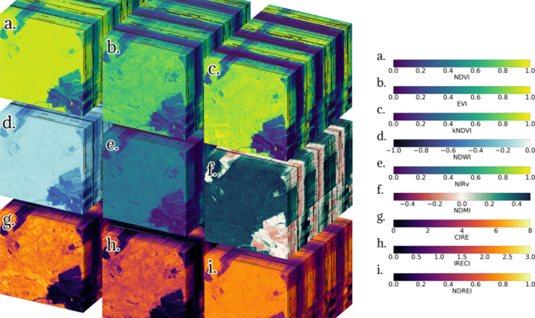
For example, the Normalized Difference Vegetation Index (NDVI), one of the most widely used band ratios, is derived by comparing the red and near-infrared bands. This index serves as a reliable indicator of vegetation health, allowing scientists to monitor forests, croplands, and grasslands with remarkable precision. Band ratios like these go beyond raw numbers; they provide a window into the underlying processes shaping our planet.
Popular Band Ratios and Their Applications
Several band ratios have become indispensable in remote sensing, each tailored to specific applications. Some of the most popular ones include:
Normalized Difference Vegetation Index (NDVI): Measures vegetation health by comparing the red and near-infrared bands.
Normalized Difference Water Index (NDWI): Highlights water bodies using green and near-infrared bands.
Soil Adjusted Vegetation Index (SAVI): Reduces soil brightness influences while assessing vegetation health.
Enhanced Vegetation Index (EVI): Offers improved sensitivity in high biomass regions by incorporating blue light reflectance.
Normalized Burn Ratio (NBR): Detects burn severity in post-fire landscapes using near-infrared and shortwave infrared bands.
Chlorophyll Index: Identifies chlorophyll content in vegetation using red-edge and near-infrared bands.
Ratio Vegetation Index (RVI): Simplifies vegetation assessment by taking the ratio of near-infrared to red bands.
Red Edge Normalized Difference Vegetation Index (RENDVI): Enhances detection of vegetation stress using the red-edge spectrum.
Each of these ratios addresses specific needs, from environmental monitoring to resource management, and continues to evolve with advancements in sensor technology.
Revealing Hidden Patterns in Landscapes
Landscapes are dynamic, constantly shaped by natural forces and human activities. Band ratios help in detecting and mapping these changes over time. By analyzing specific spectral bands, researchers can identify soil types, mineral compositions, and even the moisture content of the ground. This capability has revolutionized fields such as geology and urban planning, enabling informed decision-making.
One striking application is in the identification of minerals. Different minerals reflect and absorb light in unique ways, creating spectral signatures that can be distinguished using band ratios. Geologists use these signatures to map deposits and assess the potential for mining. Similarly, in agriculture, band ratios allow farmers to evaluate soil health, leading to more efficient and sustainable farming practices.
Monitoring Water Bodies with Precision
Water, essential to life, can reveal much about environmental health when observed through remote sensing. Band ratios play a critical role in monitoring the quality, depth, and distribution of water bodies. Specific ratios are used to detect chlorophyll concentrations, which indicate the presence of algae and can serve as an early warning sign for pollution.
In coastal and freshwater ecosystems, these techniques have transformed how scientists monitor changes caused by climate or human activity. By detecting variations in sediment levels and nutrient content, band ratios contribute to preserving delicate aquatic ecosystems. They also assist in mapping submerged features, offering insights into underwater habitats and the impacts of rising sea levels.
Advancing Climate Research and Environmental Conservation
As the planet faces unprecedented environmental challenges, band ratios have become a vital tool in climate research. Satellite imagery processed through this method allows for the precise measurement of ice cover, deforestation rates, and desertification. By comparing historical and current data, scientists gain insights into how ecosystems respond to changing climates.
Band ratios are equally instrumental in disaster management. After a wildfire, for instance, indices derived from band ratios can measure the extent of the burn and help guide reforestation efforts. In flood-prone areas, these ratios are used to assess damage and plan recovery operations. Their ability to provide timely, actionable data makes them an invaluable resource for governments, NGOs, and environmental organizations.
Challenges and the Path Ahead
While band ratios offer numerous advantages, their implementation is not without challenges. The interpretation of spectral data requires expertise, as natural and human-made factors can introduce complexities. Calibration issues and atmospheric interference also need to be accounted for to ensure accuracy.
Despite these hurdles, advancements in satellite technology and machine learning are enhancing the precision and accessibility of band ratio analysis. With these innovations, the potential applications continue to expand, from urban development to deep-sea exploration. By integrating band ratios with other remote sensing techniques, scientists are crafting a more comprehensive picture of Earth’s intricate systems.
A Technique That Illuminates Earth's Stories
The world we live in is a mosaic of interwoven systems, each telling a part of the planet's story. Band ratios provide the tools to decode these narratives, transforming spectral data into actionable insights. Whether monitoring vegetation, assessing water quality, or studying climate impacts, this technique offers a way to see beyond what is visible. In the process, it deepens our understanding of Earth and equips us to address the challenges that lie ahead.
---
Image Courtesy: Nature.com (https://www.nature.com/articles/s41597-023-02096-0)