20 Hidden Superpowers of Electromagnetic Radiation in Earth Observation
Uncover the 20 hidden secrets of electromagnetic radiation in the realm of geoinformatics. Learn how it powers satellite imagery, enhances remote sensing techniques, and reveals critical insights about Earth's surface. From mapping terrain to monitoring environmental changes, this blog explores its transformative role. Click to explore geoinformatics like never before!
GEOINFORMATICS
Dr Mahesha BR Pandit
4/20/20242 min read


20 Hidden Superpowers of Electromagnetic Radiation in Earth Observation
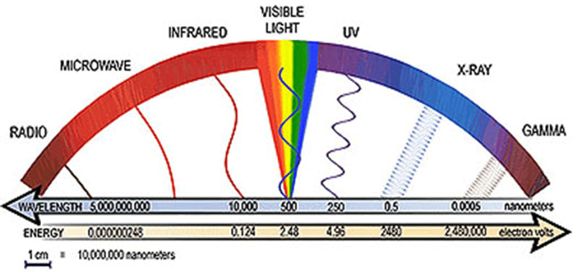
Here are 20 lesser-known facts about electromagnetic radiation (EMR) for Earth observation, converted into sentences, with their regions and approximate wavelength ranges:
Microwaves see through clouds: Microwave radiation (1 mm to 1 m) can penetrate clouds, haze, and rain, allowing satellites like Sentinel-1 to capture Earth’s surface in all weather conditions, day or night.
Infrared detects plant health: Near-infrared (NIR) radiation (0.7 to 1.3 μm) is reflected more by healthy vegetation than stressed or dead plants, making it a powerful tool for vegetation monitoring indices like NDVI.
Thermal infrared spots urban heat islands: Thermal infrared radiation (8 to 14 μm) highlights temperature differences, enabling scientists to map urban heat islands where cities are warmer than surrounding rural areas.
UV monitors ozone depletion: Ultraviolet (UV) radiation (10 to 400 nm) is used to track ozone concentrations, providing critical insights into ozone layer depletion and recovery.
Shortwave infrared identifies burned areas: Shortwave infrared (SWIR) radiation (1.4 to 3 μm) detects the reflectance of charred vegetation and soil, aiding in wildfire damage assessment and recovery tracking.
SAR for night vision of terrain: Microwave (Radar) radiation (1 mm to 1 m) is used in Synthetic Aperture Radar (SAR) to create detailed 3D maps of Earth’s surface, even in darkness or dense vegetation.
Polarized light reveals water quality: Visible and near-infrared radiation (0.4 to 1.3 μm), when polarized, helps detect water properties like turbidity, organic matter, and pollution in oceans and lakes.
Lidar measures forest canopies: Lidar uses laser pulses in the visible and NIR spectrum (0.5 to 1.1 μm) to map forest canopy structure, providing critical data for carbon stock and biodiversity studies.
Passive microwaves monitor soil moisture: Microwave radiation (1 mm to 1 m) detects subtle temperature differences to measure soil moisture, which is vital for drought and flood predictions.
Visible light analyzes chlorophyll: Visible light (0.4 to 0.7 μm) is absorbed by chlorophyll in plants, enabling the analysis of photosynthetic activity and plant health.
X-rays for mineral mapping: X-rays (0.01 to 10 nm), though rarely used in Earth observation, have potential for remote sensing of soil and rock mineral compositions.
Thermal infrared reveals volcanic activity: Thermal infrared radiation (8 to 14 μm) detects the intense heat from active volcanoes, facilitating real-time eruption monitoring.
Blue light tracks ocean depth: Blue light (0.45 to 0.495 μm) penetrates water deeper than other visible wavelengths, making it ideal for mapping shallow ocean floors and coral reefs.
UV tracks atmospheric aerosols: Ultraviolet (UV) radiation (10 to 400 nm) is used to detect aerosol particles in the atmosphere, aiding in air quality monitoring and pollution studies.
Microwaves track glacial melt: Microwave radiation (1 mm to 1 m) from satellites like GRACE measures changes in ice mass, monitoring glacial melting due to climate change.
Near-infrared detects snow properties: NIR radiation (0.7 to 1.3 μm) helps measure snow cover, depth, and melting rates by analyzing its unique reflectance properties.
Hyperspectral sensors detect oil spills: Hyperspectral imaging across visible to SWIR regions (0.4 to 3 μm) identifies oil spills by analyzing the spectral differences between oil and water.
SWIR identifies snow impurities: SWIR radiation (1.4 to 3 μm) detects impurities like black carbon in snow, which accelerates melting by absorbing sunlight.
Thermal infrared maps groundwater: Thermal infrared radiation (8 to 14 μm) identifies groundwater seepage by observing subtle temperature anomalies, particularly in arid regions.
Radar detects landslide movement: Microwave (Radar) radiation (1 mm to 1 m) tracks ground deformation, monitoring landslides and other slow geological events through radar interferometry.
Image Courtesy: Chandra X-Ray Observatory, https://chandra.harvard.edu/blog/node/336